
After a few weeks sailing around the western finger of the Peloponnese, it was time to move on to the second – known as the Mani peninsula.
It was a rushed departure from Koroni after a sleepless night of pitching and rolling. A north easterly wind had started blowing into the harbour during the early hours. Subsequently, this created an uncomfortable chop as waves coming in met waves reflected off the quayside wall. As the morning progressed I was feeling increasingly green so we tried our luck anchored off the beach instead. Once around the corner the chop disappeared but there was now a swell rolling in from the south east. This was strange as there was no wind from there.

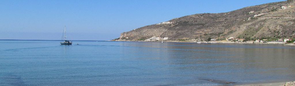
The new anchorage had a lovely setting. Blue skies, a sandy beach and the fort provided a beautiful backdrop. But unfortunately, the idyll wasn’t to last. The north wind died away and we then began to roll in the swell. Greenness returned to my gills. We scoured the weather sites looking for at least two forecasts that agreed, but it seemed today was one of those days where we had to take a lucky dip.
Limani
We decided to push on across to the second finger and the anchorage at Limeni. With the remains of the north wind we hoped to get a sail in. However, there wasn’t enough to get us through the swell, resulting in a motor sail instead. With such little wind we couldn’t understand why the sea was so chopped up. We pondered all the way across where the swell could be coming from. We got our answer about 5nm off the other side as Colin spotted a line of white horses dancing up ahead. It was as if we’d passed through an invisible force field. On one side light and variable wind, on the other an easterly F7.
Our speed subsequently dropped right off and fingers of spray splashed up Emerald’s bow. We were glad of our 75hp engine working hard to push us on. Although with the wind on the nose things weren’t too bad, much better than a wind at 30°. That direction wind creates sneaky waves that find their way into the cockpit.
A Long Slog
It was an hour long slog and even inside the bay the wind was still howling. Three other boats were anchored, spread across the half mile wide bay. Sandy patches of seabed were easy to spot. We dropped the hook in 4m and let the wind do the work of setting us. Emerald was blown sideways for a few moments until she reached the end of the released chain. Then her nose was pulled sharply back around to the wind and we knew we were well in. Looking for the anchor, we followed the line of the chain, descending into the clear water. It disappeared into the sand, and all we could spot was the top of one fluke sticking out.


A Dramatic Change in Scenery
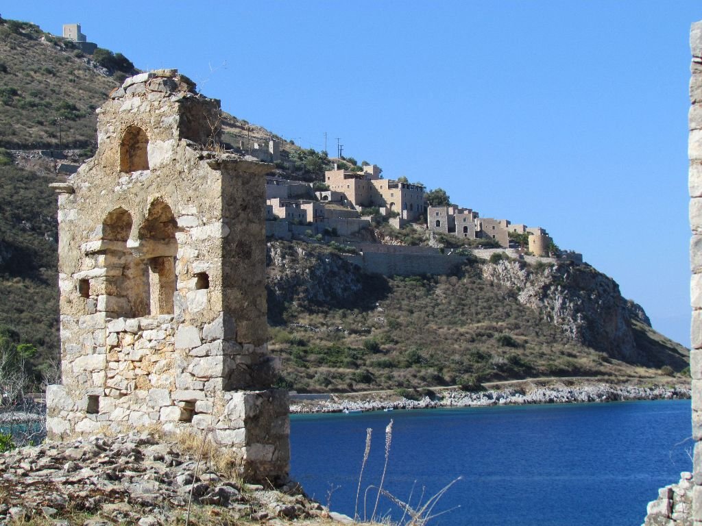
The anchorage was certainly in a dramatic setting. What a difference there is in scenery and architecture between the first and second fingers of the Peloponnese. Finger one had green hillsides covered in rows of olive trees and dotted with white painted houses. Craggy mountains with bleak hilltops scrubbed bare by the winds now ruled. Imposing tower houses stand tall on the hills, built for keeping out enemies.
Fearsome warrior tribes built these Mani style houses having settled here after the fall of Mystras. The towers purpose was to defend a clan’s land and water supplies against rival clans and invading Turkish armies. Even though the threat of invasion by enemies has been replaced by tourist feet, hotels and new builds are kept to the Mani style. The villages of Limeni and New Itayo which line the bay are just a cluster of 15 or so houses, tavernas and guest houses. In Limeni a former chieftains tower house has been restored and is now a hotel. There were very few derelict buildings as most houses have been tastefully restored.
Our rushed departure meant we hadn’t been able to get fresh bread. So, the next morning I set off along the coast road to the village of Limeni to find a shop. I found one but it had few supplies, I guess there aren’t many customers at this end of the season.

Tortoises and Castles
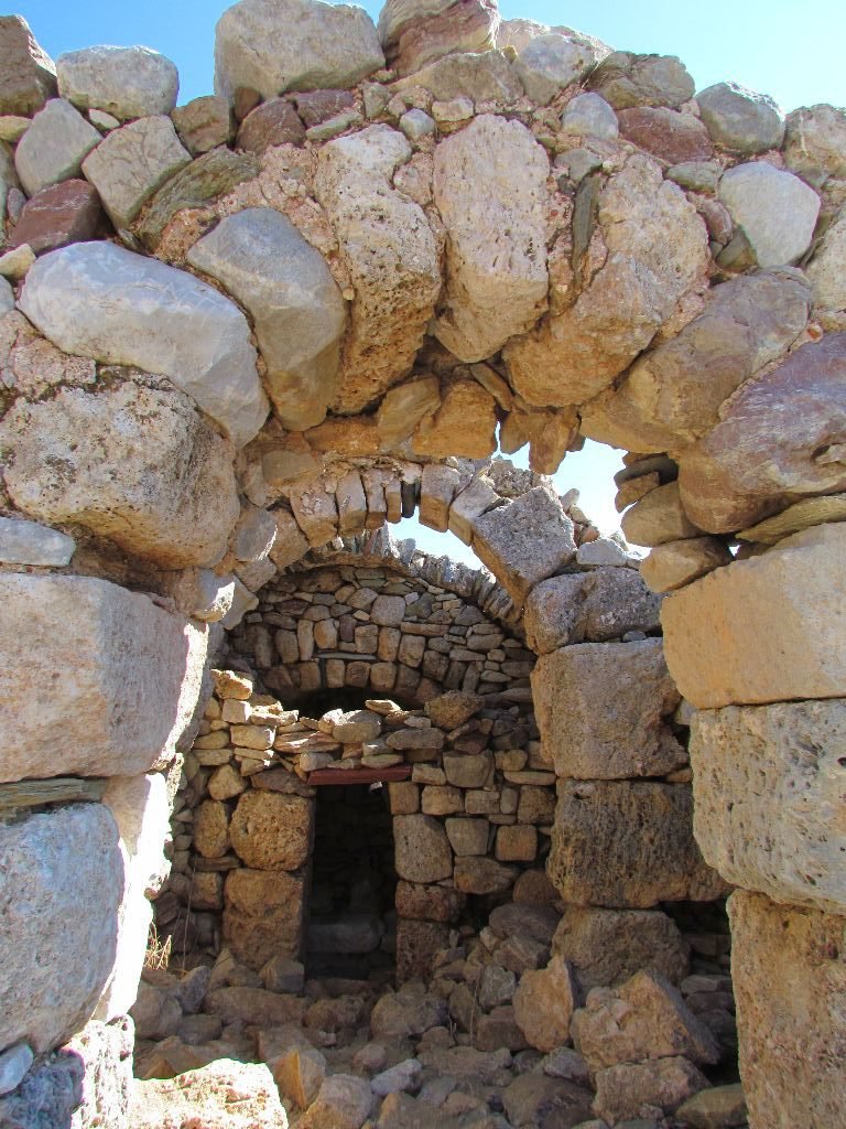
The overnight offshore winds were now turning onshore so we moved Emerald over to the north side of the bay to find a bit more shelter. I took a walk up to the ruined castle overlooking the bay, surprised to find a tortoise along the way! With the sun setting and a few clouds snagging on the mountain tops, it felt very desolate. There was something about the bleakness of the Mani that appealed to me, maybe because it reminded me of the Pennine moors near where I grew up. Images of Heathcliff stomping across a brooding landscape kept popping into my head along with Kate Bush singing away.


The Caves of Diros
The next morning we headed for the caves of Diros. Anchored off in 6m we could easily see the sandy bottom through the beautifully clear water. The entrance to the caves isn’t going to win any beauty awards with massive concrete blocks parked on the beach as wave breaks but all that changes once you’re underground. We waited 20 minutes as another group was inside before being issued with life jackets and ushered onto a flat bottomed blue boat.
Travelling by Boat
Our boatman deftly guided us around the caves, using his oar for pushing off the huge stalagmites and stalactites. It was some skill steering us down the narrow passages, making 90° turns around the formations. We sat at the back and could see how the other passengers brushed close to the walls but never touched. He didn’t say much; we thought there might have been some commentary on what we were seeing but his only utterance was a Greek expletive when he banged off the side, his only error on the whole trip.
The caves were spectacular. We could well imagine that those who first found the caves over 5000 years ago would think that they had stumbled into the entrance to hell. Water droplets glittered in the beam of the spotlights, hanging off the thousands of stalactites growing down from the caves roof. Huge columns have formed from the joining of stalagmites and stalactites, the patterns on the surface looking like alien claws. The water was crystal clear and side passages disappeared into pitch black.
The boat travels 1200m around the caves, but unfortunately we were escorted around at quite a lick and in the limited light photos came out blurred. Along with some commentary it would have been good to have stopped in a few places to take in the view. The last 300m of the caves we walked through, finally getting a chance to stop and admire.


Porto Kagio

We managed to sail a few miles on our way to Porto Kagio, drifting gently southwards from the massive headland of Cape Grosso down to the tip of the finger at Cape Taenaron. We then motored the couple of miles up around the other side and into the bay. The wind was gusty and squirrelling around from different directions but our first anchor attempt held.
Unfortunately the skipper of our neighbour boats was being an idiot. He pushed his boat towards us with his dinghy and said we were too close. He had an anchor marker so we knew our anchor was plenty far away from theirs but we moved and left them to it. Our next spot was closer in to shore and didn’t hold so well as the sand seemed much harder. However, by this point idiot boat had decided to pull his boat around and tie to shore. So, we dragged our anchor backwards until it bit into softer sand, ending up about 5m from our first drop.
Porto Kagio had the feel of a frontier town with just a few houses, three tavernas, a hotel and a parking spot for campervans. On the hillsides around were tower house hamlets, some in ruins, some with protective walls huddling the houses together.

A Walk to the End of the World
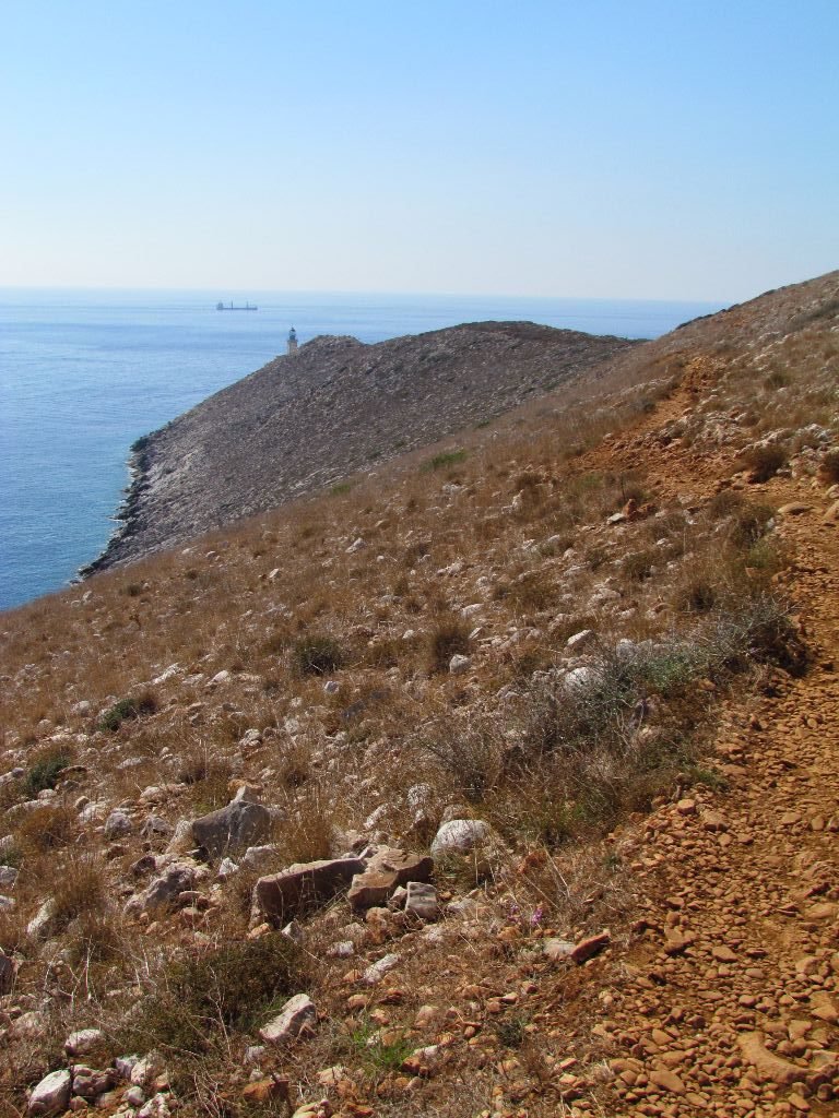
We took a walk out to the lighthouse, mostly on road which meandered it’s way through the barren landscape – rocks and bleached grass being the predominant feature. In places attempts have been made to eke some life out of the red soil with terraced vegetable plots. However, nothing much seemed to be growing except the tall urginea (sea squill) flowers, which had popped up through the dry earth and waved their white flowered heads in the breeze.
After a mile and a half the road descended to another hamlet, ending in a dirt car park. Here stood the remains of a Byzantine chapel built on the ruins of the Sanctuary and Death Oracle of Poseidon where the ancient Greeks came to worship and talk to their dead ancestors. A dirt track leads out to the lighthouse, passing some restored Roman mosaics along the way. Most of the route the walking is straight forward, but the last half mile of the track had a straight down slide to the sea 50m below, best not to trip. The weather was calm and out at the tip at the most southern point of mainland Greece the sea glittered in the sun, the wind making gentle ripples. In bad weather this would be a fearsome place to be.


Snorkels and Octopus
After the walk I had a relaxing snorkel in the clear waters. There were some shoals of small fish darting about and a few scattered remains of a wreck of what looked like a fishing boat. I didn’t find any portholes though!
We ate out that evening at one of the restaurants, it’s dangling octopus tentacles tempting us in. It turned out to be a popular choice, we’ve no idea where all the people came from but the restaurant was soon filling up.
Gythion
The next day the need for fresh supplies pushed us up inside the fingers to Gythion. A warning of rats and the prospect of stern mooring had us choosing the empty anchorage over the quayside. Gythion is a seaside town and it being a Sunday the waterside restaurants were busy but the rest of the town had a down-at-heel feel about it. We found the remains of a Roman theatre at the north end of town but unfortunately the museum of the Mani seemed very much closed. Monday morning we restocked the cupboards and headed west to the third finger.
I really enjoyed the Mani peninsular and would have liked to have spent more time there.

Sailing Info
28th September: Koroni to Lemoni, 22nm
Anchored in 4m in sand in position 36 41.603’N 22 23.176’E
30th September: Lemoni to Diros, 4nm
Anchored in 5.5M in sand in position 36 38.407’N 22 22.842’E
30th September: Diros to Porto Kayio, 28nm (7nm sailed)
Anchored in 8m in mud/sand in position 36 25.794’N 22 29.141’E
2nd October: Porto Kayio to Gythion, 22nm
Anchored in 4.5m in position 36 45.366’N 22 34.249’E